
06 Nov PAV-DT: Map-based data visualisation for road and highway maintenance
A fundamental feature of the PAV-DT solution is the visualisation of the pavement condition of roads and highways, based on a large amount of data collected by vehicle-mounted sensors. This information needs to be made available to a user in an accessible way and allows an interpretation in the geographic context of the traffic network. PAV-DT’s web-based user interface unifies a compact map-based view with a structured data presentation, with the goal of both providing information at a glance, while retaining the necessary data depth for further analysis.
A fundamental feature of the PAV-DT solution is the visualisation of the pavement condition of roads and highways, based on a large amount of data collected by vehicle-mounted sensors. This information needs to be made available to a user in an accessible way and allows an interpretation in the geographic context of the traffic network. PAV-DT’s web-based user interface unifies a compact map-based view with a structured data presentation, with the goal of both providing information at a glance, while retaining the necessary data depth for further analysis.
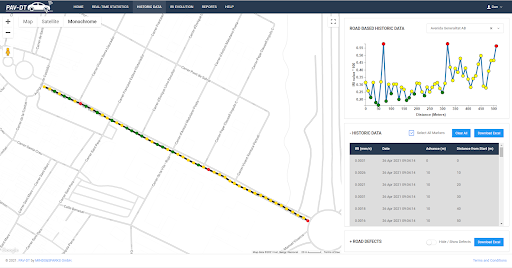
The development took advantage of state-of-the-art web development technologies, including open-source libraries for chart and graph visualization components, and a Google Maps integration for the GIS component. The later opened up the possibility to integrate Google Street View for all map implementations, which enables a user to also establish a better understanding of the local circumstances.
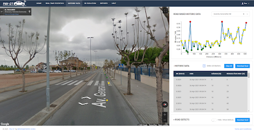
Accompanying each user interface view is an automatically scaled path-time diagram for a structured presentation of the IRI values, to simultaneously provide a map-based and a graph-based presentation of the same datasets.
The next step is an evaluation with customers to further refine the usability and functional scope of the solution.
The project PAV-DT is funded by the EU’s Horizon 2020 programme under agreement number 853899.
Members of the consortium
The PAV-DT consortium brings together five experienced partner organisations from three EU member states. The project is coordinated by BECSA (Spain) and the contributing partners include Applus Norcontrol (Spain), Micro-Sensor (Germany), Universidad Politécnica de Valencia (Spain) and MINDS & SPARKS (Austria).
The project has a duration of 30 months. MINDS & SPARKS is responsible for the development of the PAV-DT user interface with the focus on a real-time map-based data visualisation.